Municipality of Nittel
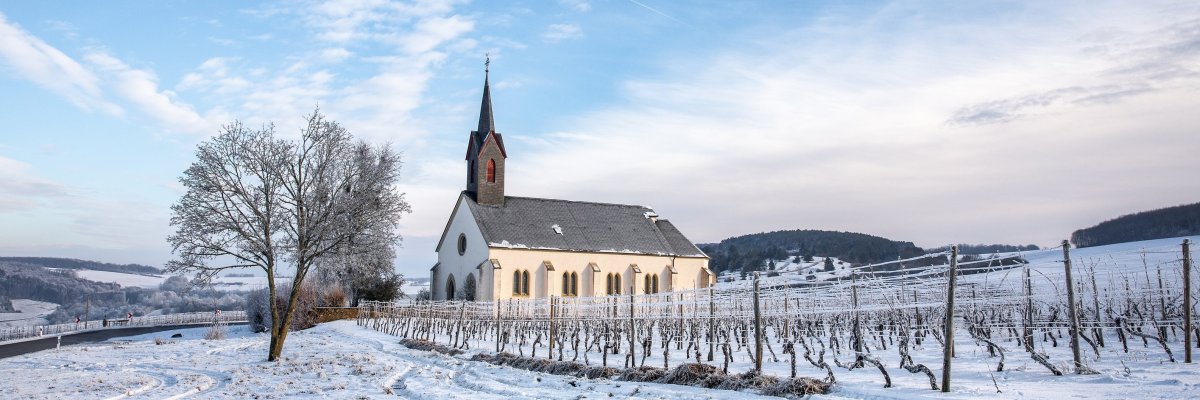
The municipality of Nittel is located 24 km south of Trier on the Upper Moselle, which here forms the border with Luxembourg. Nittel, one of the largest wine-growing communities in this region, stretches from the banks of the Moselle far up below the heights of the Moselle. Nittel is considered one of the most modern wine-growing tourist communities with a large range of accommodation.
What applies to the quality of Riesling wines for the municipality of Wiltingen (Saarland) must also apply to Nitteler Elbling wines. The high-quality wines produced from optimal locations are a pleasure for wine connoisseurs. The marketing is mostly done by the winegrowers themselves. The neighbors on the right and left are the local communities of Wellen and Wincheringen. On March 17, 1974, the previously independent communities of Köllig and Rehlingen were incorporated into Nittel.
First documented mentions come from the year 1000 as Nittel and 1034 as Nittel. On the western edge of the Saargau plateau lies the district of Köllig, which today is still heavily agricultural. The district was first mentioned in 816 as Colachech and in 1030 as Coeltische. A Roman estate was excavated south of the site. Due to its historical and ecclesiastical development, Köllig is very closely linked to Nittel. South of Nittel in a plateau basin lies the agricultural and wine-growing district of Rehlingen. In the middle of the 12th century Rehlingen was mentioned in a document as Reildinga and is said to be of Franconian origin. In modern times, one third each of this district belonged to Lorraine, Luxembourg and Electoral Trier.
Sights - e.g.
Roman brick kiln, Nittel-Rehlingen
A preserved brick kiln from the 2nd or 3rd century was excavated in Nittel-Rehlingen. The Keuper material used to fire roof tiles – a kind of marl made from shell limestone – was mined near the plant. Ships then brought the finished products to Trier. The hearth with the combustion chambers, the arches, the service room, the center aisle, the side fire arresters and the inspection areas are well preserved. While the Romans erected stone buildings and needed bricks for them, the Franconian Carolingians that followed preferred wooden houses. For this reason, the Franks no longer put the brick kilns into operation. Instead, they used the buildings for residential purposes.
Nitteler Fels nature reserve
The Nitteler Fels nature reserve is located between the Nittel and the wells. High dolomite and limestone rocks form an impressive panorama and provide a habitat for endangered animals and plants, especially for birds, insects, reptiles, bats and orchids. The zone has a favorable climate, as can be seen from the variety of plants. Numerous plant species native to the Mediterranean region, such as orchids, pear, euonymus, viburnum and boxwood grow here. This includes species of orchids that bloom on dry grass above the rocks. Hawthorn, green cherry and cornel also thrive here. The favourable, continental climate is due to the sheltered location between the Gutland plateaux.
Elbling Wine Trail Nittel
Long before the time of Roman settlement, the Treverer Celtic tribe is said to have cultivated wine on the Moselle under Greek influence. The further refinement of this culture can be attributed to the Romans. The Elbling is probably the oldest grape variety on the Moselle. In Nittel, with 290 hectares of vineyards the largest wine-growing community on the Upper Moselle, it covers around 75% of the area under cultivation and is therefore characteristic of the region.
The local limestone soil gives it a very special flavor. This dry white wine is lively, racy, stimulating, refreshing and easily digestible. It is also very suitable for processing into sparkling wine. In addition to the Elbling, Burgundy mature into sophisticated wines here. Auxerrois, Pinot Blanc and Pinot Gris thrive on the limestone soil of the Upper Moselle, which stretches all the way to the French Massif Central.
Discover the world of wine on a 1 1/2 - 2 hour hike on the Upper Moselle, the slightly different part of the Moselle. Let a wine experience guide explain what "Elbling" and "Auxerrois" are and why "Riesling" only plays a minor role in this section of the Moselle.
Heraldry (Heraldry)
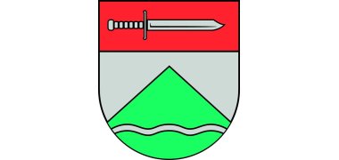
The coat of arms from 1953 shows a lying sword in a red shield head, a green mountain in a silver shield, covered with a silver wavy bar.
From the justification for the coat of arms draft of March 19, 1953: The municipality of Nittel, located directly on the Moselle, has the third largest wine-growing district in Germany. Their entire economic life is determined by viticulture. When the coat of arms was formed, however, a conscious decision was taken not to indicate this fact by including a bunch of grapes in the coat of arms design. In too many wine-growing communities this sign can be found in the coat of arms. It was therefore necessary to look for another sign that was characteristic of Nittel and at the same time closely and directly related to viticulture. This may have been found by including the well-known "Nitteler summit". The "Nitteler summit" is the largest and best-known wine-growing area in the community and has the reputation of embodying the best location in town. This so-called "Nitteler summit" is shown on the sign. The severed shield head shows a lying sword in red. Here the reference is made to the church patron of Nittel, St. Martin, whose sword returns in the main shield.


